


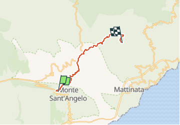
Monte Sant'Angelo - Monte Sacro

jeanmarcMasson
User GUIDE

Length
16.7 km

Max alt
857 m

Uphill gradient
641 m
Km-Effort
25 km

Min alt
460 m

Downhill gradient
600 m
Boucle
No
Creation date :
2024-12-13 18:14:32.953
Updated on :
2024-12-13 18:22:21.015
5h42
Difficulty : Very difficult

FREE GPS app for hiking
 SityTrail
IGN / Geographical institutes
SityTrail Plus
The world is yours!
About
Trail Walking of 16.7 km to be discovered at Apulia, Foggia, Monte Sant'Angelo. This trail is proposed by jeanmarcMasson.
Positioning
Country:
Italy
Region :
Apulia
Department/Province :
Foggia
Municipality :
Monte Sant'Angelo
Location:
Unknown
Start:(Dec)
Start:(UTM)
579415 ; 4617767 (33T) N.
Comments